Animals
 Animation
 Art of Playing Cards
 Drugs
Drugs Education
 Environment
 Flying
 History
 Humour
 Immigration
 Info/Tech
 Intellectual/Entertaining
 Lifestyles
 Men
Men Money/Politics/Law
 New Jersey
 Odds and Oddities
 Older & Under
 Photography
 Prisons
 Relationships
 Science
 Social/Cultural
 Terrorism
 Wellington
 Working
 Zero Return Investment
How Green Was My Valley
Rural OutlookFrom a newspaper advertisement: "Dog for sale: eats anything and is fond of children. To err is human, to moo bovine. - Weird Wellington Happenings and Links
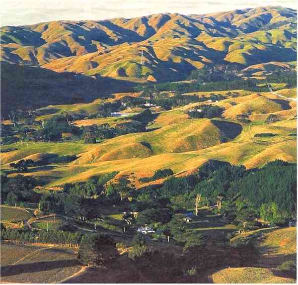
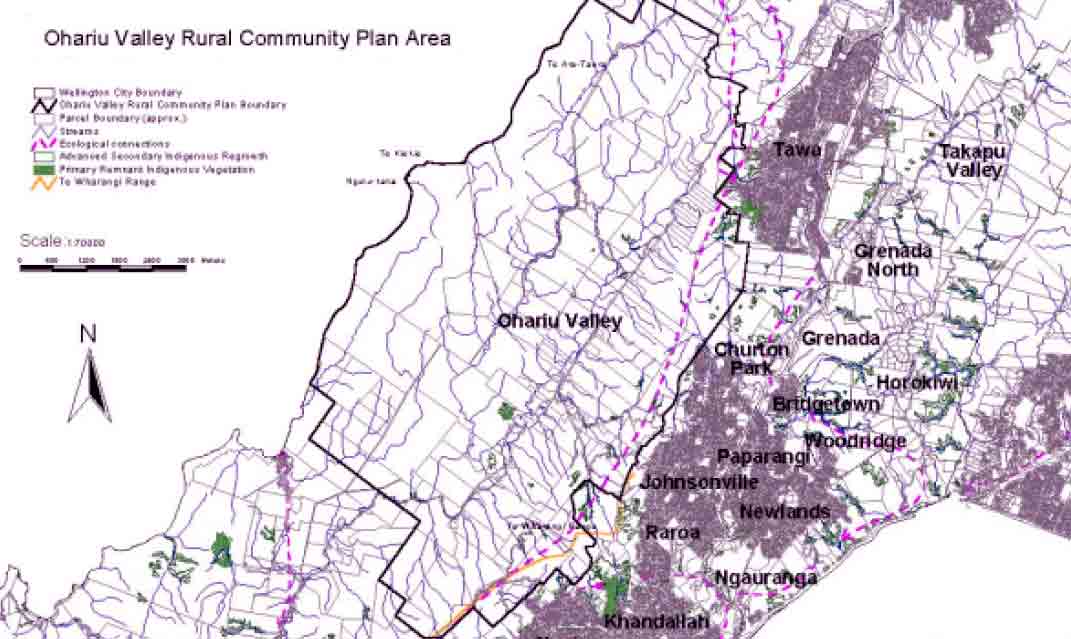
Green and Pleasant: Ohariu Valley is part of our rural city. Should this scene radically change? For a lot of people, Wellington is summed up by the harbour, tall buildings, commuters, cafes and swank apartments. Therefore it's easy to forget that most of the city's land is rural. Around 64% of the city's total 29,000-hectare area is classified as Rural in the District Plan - including rugged hill country, rolling farmland and spectacular and isolated coastline. In other words, the city's rural areas can't be ignored. As part of the work toward a Ten Year Plan, a draft Rural Area Policy has been prepared to outline some proposed objectives for rural !and. These objectives will help guide the Council, and the community in managing rural issues over the next decade. Issues include:
Some of the information used in the Draft Policy has come from work already done on reviewing the rural provisions in the District Plan. Consultation earlier this year demonstrated that there is a need for the Council and those with an interest in the rural area to set some overall objectives before making any changes to the District Plan. The main ambition of the early European settlers was to farm their land, but they first had to clear it of dense forest. This led to extensive sawmilling operations in Ohariu and for many years the pioneers earned their living from the sale of logs, sawn timber, and firewood. In 1916 the first dairy was established, and soon a number of farmers began delivering their own milk in to Wellington. Over time, sheep farming also assumed importance in Ohariu Valley. Farming is still an integral part of the Ohariu Valley, and in a sense dominates the landscape with its open, pastoral hill country. Source: Absolutely Positively Wellington (the Wellington City Council newsletter)
Subdivision is a very topical issue in the community, and residents express a range of opinions on whether additional subdivision is desirable. Farmers in the Valley wish to have the ability of some very limited subdivision to assist them in maintaining their farming operations. Others, however, are generally opposed to further subdivision. A few consider the rules regarding subdivision should be made a lot more flexible. In general, however, the community is opposed to widespread "lifestyle block" subdivision. Traffic safety and roading are 'burning' issues expressed by residents. The Community is particularly concerned about speeds on the roads in the area. Key proposals include erecting signs at the entrance to the valley to encourage safer driving habits and having ongoing discussions with landowners around the issue of public access and riparian management.
Objective 1 below was identified by the Community as the overarching principle which should guide Ohariu Valley’s future followed by a range of secondary objectives.
Source: wellington.govt.nz 2001
Not a lot seems to have happened since. Nowadays, Ohariu Valley is still home to a number of farms, but there are also horse riding schools and holding paddocks, farmstays, lifestyle blocks, the Ohariu Golf Course (10 greens and 18 tees) and lodges. The Valley Road is popular for cycling and recreational driving. Its winding course follows the contours of streams and valleys all the way to the coast at Makara.
Council Debates Farmland Changesby Ann-Marie Johnson Some people would be happy to see more development of the city's rural areas but opponents are keen to keep it green. Ohariu Valley farmland could become covered in housing developments under new planning proposals, Wellington city councillor Helene Ritchie fears. Two council committees will hold a joint meeting to debate a set of 15 new planning objectives to cover the city's rural areas, including Makara, Ohariu Valley and Horokiwi. The objectives will be used as a guideline to develop more detailed community plans for each area, which could lead to changes to District Plan development rules. Cr Ritchie, a mayoral candidate who lives in Ohariu Valley, said the proposed objectives appeared to encourage more subdivision and development. One objective is "to provide opportunities for rural living where the environment and local infrastructure is able to support and accommodate growth". Another says the capacity of rural roads should be increased to cope with the effects of rural living. "What I see and read in this is the ability for developers to come in and develop another Pauanui," Cr Ritchie said. "There's nothing to stop that kind of subdivision. We'll see lots of very haphazard growth." Cr Ritchie is on sick leave from the council after a recent operation but said she felt so strongly about the issue that she would attend the meeting tomorrow. The objectives were developed after public consultation last year, but submissions showed the community was divided over whether more development and better roading was wanted, she said. Improving the safety of rural roads was a higher priority than increasing their capacity. Council city development and business committee chairwoman Sue Piper said today it was too early to say what effects the objectives might have on rural development. The smallest blocks allowed in Ohariu Valley were 50ha but the Environment Court had warned the current subdivision rules were inadequate, Cr Piper said. "There are competing issues - the people living out there now, farmers struggling to get by and the wider amenity values for the city as a whole." The council had to balance those conflicts, she said; the public would be further consulted when the community plans were drawn up. Environment and recreation committee chairman Andy Foster said there was a strong division of views between people who wanted more development and those who wanted the rural area to stay as it was. "I don't think anybody is really envisaging there will be a massive change." The public would be consulted before any changes were made to the District Plan, he said. Source: The Evening Post Tuesday 30 January 2001
Fast FaxThe City Council owns 2,900 hectares of open space around the city, of which 2,101 hectares is protected. In total, it is estimated that Wellington has 5,623 hectares of open space. This means that for each person in the city, there is approximately one tennis court area of public green space. The City Council owns and maintains 154 parks and reserves. There is 2,500 ha of bush, 200 ha of grass, 100 ha of sportsfields, and 98.5 km of maintained tracks through the greenbelts. Some 39% of residents either use the cable car, buses, trains, or walk or bike as their primary travel method into the city on most weekdays. Source: A Public Summary of Wellington's State of the City Report: An Owner's Guide to Life in Wellington 2000 produced by the Wellington City Council
For satellite photos and pictures of Wellington from several different angles and for articles about earthquakes, history, business, the Ohariu Valley, statistics, fireworks, the
national anthem, the kiwi icon and more click the "Up" button below to take you to the Index for this Wellington section. |