Preparing for the Inevitable
We want a story that starts out with an earthquake and works its way up to a climax.
- Samuel Goldwyn
Source: Wellington City Council Newsletter November 2000

City councillors included these words:
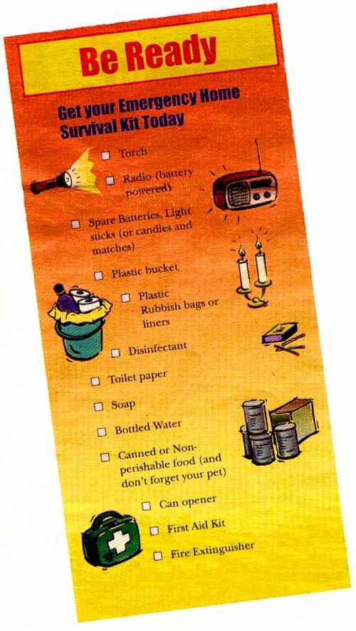
Your "Be Ready" Shopping List
Enclosed in this issue of Absolutely Positively Wellington is a brightly-coloured shopping list to help you build your "Be Ready" emergency home survival kit.
On it are the essential items you'll need. Take the list with you to your favourite supermarket and start building your kit. You don't have to do it all at once,
especially if money's a bit tight - but it is important to get started. In a major earthquake or emergency you are likely to have to take care of yourself and the others in your
house for at least three days without help, and probably without water, power or gas.
So we're trying to make it easy for you to look after yourself in an emergency.
We'd also like to remind you that there are other things you need to think about now - like extra supplies of essential medications, and a family plan for reuniting with each other
if separated.
For more free shopping lists call the Wellington Emergency Management Office on (04) 499 4444.
Source: Absolutely Positively Wellington (the Wellington City Council newsletter) November 2000
Unfortunately, in the newsletter I saw, the shopping list wasn't enclosed. All I have is the illustration they printed above their article, so I don't really know what are the
"reminders of other things" I "should be thinking about" they said were written on the reverse. However, I saved the list printed by the Wellington Emergency Management Office
(WEMO) before the Y2K [non-]crisis. It sounded like it would leave survivors fairly prepared, so I've included it instead:
Check the List
Your kit should contain the items that you will need if there is interruption to services such as power, gas, water, banking, telecommunications and the supply of products such as
food and medicines. You should have enough to last three days.
You should have
 | Canned and preserved food such as dried food, milk powder and fruit juice. You will also need to provide for pets and members of your household who have special needs such
as babies. If electricity fails use the fresh food in the refrigerator first and then the frozen items. |
| Water. You should store 3-5 litres per person per day. More information on how to store water and get water from your hot water cylinder, is available from WEMO. |
| An alternative cooking source such as a BBO or Primus. Check your gas bottles to make sure that they are full. Make sure you have matches or lighters to light this but
keep them away from children. |
| Alternative lighting such as torches and light sticks (available from camping shops). Make sure you have a good supply of fresh batteries for your torches as well. |
| A portable radio and batteries. In an emergency, you can use your radio (or car radio) to find out what is going on. You will need a supply of spare batteries for your
portable radio as well. |
| Medication. Make sure that you have adequate supplies of any medication or special equipment you need. |
| Hygiene items. If there is no sewage, you may have to make an emergency toilet. Use a plastic bag in a bucket or the toilet bowl. Make sure you have
disinfectant and spare toilet paper. |
| Spare cash and cheques. You may not be able to rely on electronic transactions so it's a good idea to have some spare cash and cheques. However don't keep large
amounts of cash in your home. |
Possibly this list would be a good start for the types of things to be sent in aid to India, recently stricken with a 7.9 earthquake.

The Sound of the 26 December 2004 Earthquake
Source: earth.columbia.edu
The Richter Scale - What It Is and What It Means
Most people have heard of the Richter scale - the measure of the strength of an earthquake - but what does it really measure and what does it mean?
The United States Geological Survey estimated that Friday's quake that killed thousands in India measured 7.9 on the scale. The quake that killed 2,400 people in Taiwan in
September 1999 measured 7.6 - so does that mean the Indian quake was just slightly stronger the one in Taiwan?
The answer is no.
As the strength of earthquakes rises in steps up the Richter scale, each quake releases 31 times more energy than the one at the previous notch.
Introduced in 1935, the scale is named for American physicist Charles F Richter of the California Institute of Technology, who evolved it from patterns he discovered by studying more
than 200 earthquakes a year. The Richter scale is a more objective, quantitative basis of measuring quakes than the other widely-used standard, the 12-point Mercalli scale, the US
Geological Survey says. It does not measure an earthquake's effects, but gives its strength in terms of the energy released, as measured by seismographs.
The scale starts at one and has no upper limit; each unit is 10 times greater than the one before. Mathematicians refer to this method of arranging numbers on a scale as
logarithmic. For instance, the survey says, a magnitude of 5.3 might be calculated for a moderate earthquake, and a strong earthquake might be classed as magnitude 6.3. But
because the Richter scale has a logarithmic basis, each whole number increase in magnitude on the scale represents a 10-fold increase in an earthquake's measured amplitude.
A quake's strength is ranked on the basis of the maximum amplitude of the signal recorded by a seismograph and how far the instrument is from the earthquake; state-of-the-art seismic
systems use telephone lines and satellites to link to a central computer, which churns out preliminary results within minutes.
Earthquakes with a magnitude of about two or less are called microearthquakes; people don't usually feel them and they are usually tracked only by local seismographs. Events
ranking about 4.5 or greater - of which there may be several thousand every year - are strong enough to be recorded by sensitive instruments all over the world. Great earthquakes,
such as the 1964 Good Friday earthquake in Alaska, have magnitudes of 8.0 or higher. The San Francisco earthquake of 1906 has since been calculated at 8.3.
Another in Mexico in 1985 registered 8.1 on the scale.
On average, one earthquake of such size occurs somewhere in the world each year, the US Geological Survey says.
The Richter scale has no upper limit, but the largest known shocks have had magnitudes in the 8.8 to 8.9 range.
In 1950, a quake measuring 8.6 on the scale struck northeast India, killing hundreds of people. In a quake measuring possibly NINE on the scale, more than 830,000 people
died when the most devastating earthquake in recorded history hit China's Shaanxi province in 1556. China suffered the worst quake in its modern history on 28 July 1976 when the
northeastern city of Tangshan was completely razed, and at least 240,000 people, possibly hundreds of thousands more, were killed. The Richter reading was 7.8.
The Mercalli scale, by contrast, is more subjective in assessing the effect of earthquakes. For example, an earthquake registering five on the Mercalli scale is defined as
having made furniture to shake and church bells ring, but triggering little or no damage. - Reuters
Source: The Evening Post Tuesday 30 January 2001
Not everyone agrees about "the most devastating earthquake in recorded history...
The worst earthquake in recorded history happened in the Middle East along the coast of the Mediterranean Sea in the year 1201. From manuscripts and illustrations written about
the event shortly afterwards, historians have determined that over one million people lost their lives. Earthquakes are measured on a scale of one through nine that was developed
by two seismologists, Charles Richter and Beno Gutenberg. A "1" score means the tremor is only felt by scientific instruments, while a "7" score means that buildings have been
destroyed. A "9" score has never been recorded.
Source: yahooligans.com
Most Destructive Known Earthquakes on Record in the World
(50,000 deaths or more, listed in order of greatest number of deaths)
|
Date |
Location |
Deaths |
Magnitude |
Comments |
| 1556 Jan 23 |
China, Shansi |
830,000 |
9? |
|
| 1737 Oct 11 |
India, Calcutta** |
300,000 |
|
|
| 1976 Jul 27 |
China, Tangshan |
255,000* |
8.0 |
|
| 1138 Aug 8 |
Syria, Aleppo |
230,000 |
|
|
| 1927 May 22 |
China, near Xining |
200,000 |
8.3 |
Large fractures |
| 856 Dec 22 |
Iran, Damghan |
200,000 |
|
|
| 1920 Dec 16 |
China, Gansu |
200,000 |
8.6 |
Major fractures, landslides |
| 2004 Dec 26 |
Banda Aceh, Indonesia |
175,000+ |
9.3 |
Tsunami in Indian Ocean |
| 893 Mar 23 |
Iran, Ardabil |
150,000 |
|
|
| 1923 Sept 1 |
Japan, Kwanto |
143,800 |
8.3 |
Great Tokyo fire |
| 1948 Oct 5 |
USSR |
110,000 |
7.3 |
Turkmenistan, Ashgabat |
| 1908 Dec 28 |
Italy, Messina |
70-100,000 |
7.5 |
Earthquake and tsunami |
| 1290 Sep ? |
China, Chihli |
100,000 |
|
|
| 1667 Nov ? |
Caucasia Shemakha |
80,000 |
|
|
| 1727 Nov 18 |
Iran, Tabriz |
77,000 |
|
|
| 1755 Nov 1 |
Portugal, Lisbon |
70,000 |
8.7 |
Great tsunami |
| 1932 Dec 25 |
China, Gansu |
70,000 |
7.6 |
|
| 1970 May 31 |
Peru |
66,000 |
7.8 |
Great rock slide, floods |
| 1268 ? ? |
Asia Minor Silicia |
60,000 |
|
|
| 1693 Jan 11 |
Italy, Sicily |
60,000 |
|
|
| 1935 May 30 |
Pakistan, Quetta |
30-60,000 |
7.5 |
Near complete destruction |
| 1783 Feb 4 |
Italy, Calabria |
50,000 |
|
|
| 1990 Jun 20 |
Gilan, Iran |
50,000 |
7.7 |
Landslides |
* Official casualty figure - estimated death toll as high as 655,000.
** Later research has shown that this was a typhoon, not an earthquake according to The 1737 Calcutta Earthquake and Cyclone Evaluated by Roger Bilham, BSSA, Vol 84 No 5
October 1994
Data compiled from several sources including United States Geological Survey and the National Earthquake Information Center.
Source: madsci.org
The Top 10 Earthquakes for the US According to the USGS:
- Prince William Sound, Alaska 1964, 9.2
- Andreanof Islands, Alaska 1957, 9.1
- Rat Islands, Alaska 1965, 8.7
- East of Shumagin Islands, Alaska 1938, 8.2
- New Madrid, Missouri 1811, 8.1
- Yakutat Bay, Alaska 1899, 8.0
- Andreanof Islands, Alaska 1986, 8.0
- New Madrid, Missouri 1812, 8.0
- Near Cape Yakataga, Alaska 1899, 7.9
- Fort Tejon, California 1857, 7.9
More
Earthquakes have claimed hundreds of thousands of lives in the last 100 years and improvements in technology have only slightly reduced the death toll.
| 26 December 2003: Southeastern Iran, magnitude 6.5; government estimates at least 40,000 killed. |
| 1 May 2003: Southeastern Turkey, magnitude 6.4; 167 people killed, including 83 children in a collapsed dormitory. |
| 24 February 2003: Western China, magnitude 6.3 or 6.8; at least 266 killed. |
| 22 June 2002: Northwestern Iran, magnitude 6; at least 500 killed. |
| 12 April 2002: Dozens of people are killed in the third large tremor to hit northern Afghanistan in two months. |
| 25 March 2002: Second earthquake in a month in Afghanistan. At least 800 die in the north of the country (some sources say
1,000). The earthquake registers 6.0 (or maybe 5.8) on the Richter scale. |
| 3 March 2002: Some 150 killed by earthquake in Afghanistan centred on Samangan province. It registers 7.2 on the Richter
scale. |
| 3 February 2002: An earthquake registering 6.0 on the Richter scale strikes western Turkey, leaving at least 43 people dead and
thousands homeless. |
| 24 June 2001: An earthquake lasting more than a minute hits southern Peru, killing at least 47 people and injuring hundreds. It
measured 7.9 on the Richter scale. |
| 13 February 2001: Nearly 300 people are killed as the second earthquake in a month hits El Salvador. The latest quake measures
6.6 on the Richter scale. |
| 26 January 2001: An earthquake measuring 7.9 on the Richter scale devastates much of Gujarat state in north-western India, killing an
estimated 30,000 people and making more than a million homeless. Bhuj and Ahmedabad are among the towns worst hit. Other sources say at least 2,500 killed and
estimates put death toll as high as 13,000. |
| 13 January 2001: El Salvador is devastated by an earthquake measuring 7.6 on the Richter scale. More than 700 people die. |
| 21 September 1999: Taiwan is hit by a quake measuring 7.6 on the Richter scale that kills nearly 2,500 people and causes damage to
every town on the island. |
| 17 August 1999: An earthquake measuring 7.4 on the Richter scale rocks the cities of Izmit and Istanbul in Turkey, leaving more than
17,000 dead and many more injured. |
| March 1999: Uttar Pradesh in northern India is hit by two earthquakes in as many days, killing more than 100. |
| 25 January 1999: A shock measuring 6.0 kills up to 1,000 in the town of Armenia in western Columbia. Other sources say 1,171
killed. |
| July 1998: More than 1,000 are killed after a tsunami or sea wave, caused by an undersea earthquake, wipes out communities on the
north-western coast of Papua New Guinea. |
| June 1998: Adana in south-eastern Turkey is shaken by an earthquake measuring 6.3 which claims 144 lives. A week later the same
area suffers two strong aftershocks, leaving more than 1,000 people injured. |
| 30 May 1998: Northern Afghanistan and Tajikistan is hit by a major earthquake, magnitude 6.9, killing 4,000 people (some
sources say as many as 5,000 were killed). |
| 10 May 1997: Northern Iran, magnitude 7.1; 1,500 killed. |
| February 1997: A quake measuring 5.5 tears apart rural areas of north-western Iran, killing 1,000 people. Three months later a
stronger tremor, measuring 7.1, kills 1,560 in eastern Iran. |
| May 1995: The far eastern island of Sakhalin is hit by a massive earthquake, measuring 7.5, which claims the lives of 1,989
Russians. |
| 17 January 1995: The Hyogo quake, magnitude 7.2, hits the city of Kobe in Japan, killing 6,430 people. |
| June 1994: About 1,000 people are killed by an earthquake and ensuing landslide in Colombia. |
| 30 September 1993: About 10,000 villagers are killed in western and southern India, mainly around Latur, magnitude 6.0. |
| 21 June 1990: Northwest Iran, magnitude 7.3 - 7.7; 50,000 killed. |
| October 1989: The Loma Prieta earthquake hits California, killing 68 people. |
| 7 December 1988: An earthquake measuring 6.9 on the Richter scale devastates northwest Armenia, killing 25,000 people. |
| 19 September 1985: Mexico City and central Mexico is shaken by a huge earthquake, magnitude 8.1, which razes buildings and kills
10,000 people. (Other sources say 9,500 killed.) |
| 1980: Hundreds are killed by tremors which ripple through southern Italy. |
| 16 September 1978: Northeast Iran, magnitude 7.7; 25,000 killed. |
| 28 July 1976: Tangshan, China; magnitude 7.8 - 8.2; 240,000 killed. |
| 4 February 1976: Guatemala, magnitude 7.5; 22,778 killed. |
| 1960: The world's strongest recorded earthquake devastates Chile, with a reading of 9.5 on the Richter scale. A tsunami 30ft
(10m) high eliminates entire villages in Chile and kills 61 hundreds of miles away in Hawaii. |
| 1948: The Fukui quake, centred in the East China Sea, devastates western Japan, killing 3,770. |
| 26 December 1939: Erzincan province, Turkey, magnitude 7.9; 33,000 killed. |
| 24 January 1939: Chillan, Chile, magnitude 8.3; 28,000 killed. |
| 1935: Taiwan is hit by a tremor measuring 7.4 on the Richter scale, which kills 3,276 people. |
| 31 May 1935: Quetta, India, magnitude 7.5; 50,000 killed. |
| 1 September 1923: Tokyo-Yokohama, Japan, magnitude 8.3; at least 140,000 killed. |
| 1906: San Francisco is hit by a series of violent shocks which last up to a minute. Between 700 and 3,000 people die either
from collapsing buildings or in the subsequent fire. |
Sources: news.bbc.co.uk Saturday 22 June 2002 and story.news.yahoo.com Saturday 27 December 2003 from the Associated Press
What is fascinating to me is that these two sources each had articles reputedly covering the same thing - deadly earthquakes over the past century - yet there was little overlap
and the earthquakes that were common to each list sometimes gave very different figures. Apparently earthquake evaluation and reporting is hardly a science, even today.
The Great Prince William Sound Earthquake of 28 March 1964
by Doug Christensen, Phd
| Epicentral Parameters
 | Origin Time - 28 March 1964 03:36:14.0 GMT (27 March 05:36:14.0pm local time) |
| Location - Latitude 61.04 N - Longitude 147.73 W depth approximately 25km. The epicenter was about 10km east of the mouth of
College Fiord, approximately 90km west of Valdez and 120km east of Anchorage. |
| Magnitude - 9.2 (Moment Magnitude) Second largest earthquake ever recorded. The largest was a 9.5 earthquake in Chile in
1960. |
| Duration of Rupture - approximately 4 minutes (240 seconds) |
|
| Aftershocks - The aftershock zone of this earthquake was about 250km wide and extended about 800 km from Prince William Sound to the
SW end of Kodiak Island. The mainshock and its aftershocks occurred on a fault which is part of the boundary between the Pacific and North American plates. Thousands of
aftershocks were recorded in the months following the mainshock. In the first day there were 11 aftershocks with magnitude greater than 6.0 on the Richter scale; in the next
3 weeks there were 9 more. Smaller aftershocks continued for more than a year. |
| Cause - The northwestward motion of the Pacific plate at about 5 to 7cm/year causes the crust of southern Alaska to be compressed and
warped, with some areas along the coast being depressed and other areas inland being uplifted. After periods of tens to hundreds of years, this compression is relieved by the
sudden southeastward motion of portions of coastal Alaska as they move back over the subducting Pacific plate.
As a result of the 1964 quake, the Latouche Island area moved about 18 metres to the southeast. Also, the patterns of uplift and subsidence which had been slowly developing
prior to the earthquake were suddenly reversed, with areas around Montague Island being uplifted 4-9 metres and areas around Portage down-dropped as much as 3 metres. The
hinge line (line of no vertical change separating the uplift and subsidence zones) extended from near the epicenter in Prince William Sound to the SE coast of Kodiak
Island. This vertical deformation affected and area of approximately 250,000sqkm (100,000sqmi). The end results was the movement of the Pacific plate under the North
American plate by about 9 metres on average. |
| Outcome
| Damage - The area where there was significant damage covered about 130,000sqkm. The area in which it was felt was about
1,300,000sqkm (all of Alaska, parts of Canada, and south to Washington). The four minute duration of shaking triggered many landslides and avalanches. Major structural
damage occurred in many of the major cities in Alaska. |
| Losses - Deaths: 115 in Alaska, 16 in Oregon and California. The death toll was extremely small for a quake of this
size, due to low population density, time of day (holiday) and type of material used to construct many buildings (wood). Damage: 300-400 million dollars (1964
dollars). |
| Water Waves - Much of the damage and most of the lives lost were due to the effects of water waves. These were mainly of two
kinds: the tsunami of open-ocean sea wave, generated by large-scale motion of the sea floor; and the local wave, generated by underwater landslides in bays of fiords. The
1964 Alaska tsunami was the second largest ever recorded, again following only the one caused by the 1960 Chile earthquake (4 metres at Sitka). Of the 119 deaths
attributable to the effects of the ocean, about 1/3 were due to the open-ocean tsunami: 4 at Newport Beach, Oregon; 12 at Crescent City, California; and about 21 in
Alaska. Local waves claimed at least 82 lives. Maximum height reported for these waves were 70 metres in Valdez Arm. Seiches, a sort of sloshing
of water back and forth in a small body of water like a boat harbour or swimming pool, were observed as far away as Louisiana where a number of fishing boats were
sunk. Oscillations in the height of water in wells were reported from as far away as South Africa. |
| Seismic Waves - In addition to damage in the epicentral region immediately following the quake, long period seismic waves travelled
around the earth for several weeks. Basically the whole earth vibrated (rang) like a church bell during this time. States as far away as Texas and Florida were
affected with vertical motions of up to 5 to 10cm. |
|
Doug Christensen is with the Geophysical Institute University of Alaska Fairbanks
Source: aeic.alaska.edu
The largest earthquake in the world since measurements have been made was a 9.5-magnitude event that shook Chile in 1960. The 1964 Alaskan quake above had held the #2 spot
globally until scientists provided an updated estimate of the 26 December 2004 tsunami-causing Sumatran earthquake. That event has now been pegged at 9.3.
The Rule of Threes
A person can live for:
| Three seconds without thinking |
| Three minutes without air |
| Three hours without shelter |
| Three days without water |
| Three weeks without food |
| Three months without hope |
Source: American Survival Guide November 1997
For satellite photos and pictures of Wellington from several different angles and for articles about earthquakes, history, business, the Ohariu Valley, statistics, fireworks, the
national anthem, the kiwi icon and more click the "Up" button below to take you to the Table of Contents for this Wellington section.
|
 Animals
 Animation
 Art of Playing Cards
 Drugs
Drugs Education
 Environment
 Flying
 History
 Humour
 Immigration
 Info/Tech
 Intellectual/Entertaining
 Lifestyles
 Men
Men Money/Politics/Law
 New Jersey
 Odds and Oddities
 Older & Under
 Photography
 Prisons
 Relationships
 Science
 Social/Cultural
 Terrorism
 Wellington
 Working
 Zero Return Investment