Animals
 Animation
 Art of Playing Cards
 Drugs
Drugs Education
 Environment
 Flying
 History
 Humour
 Immigration
 Info/Tech
 Intellectual/Entertaining
 Lifestyles
 Men
Men Money/Politics/Law
 New Jersey
 Odds and Oddities
 Older & Under
 Photography
 Prisons
 Relationships
 Science
 Social/Cultural
 Terrorism
 Wellington
 Working
 Zero Return Investment
Sea Level Variation Is Natural
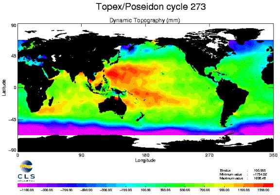
The Poseidon AdventureIt is better to debate a question without settling it than to settle a question without debating it. - Jeseph Joubert by John L Daly The use of satellites equipped with altimetry instruments (particularly the Topex/Poseidon satellites) has revealed a sea level profile that hardly was guessed at before the advent of satellites. Instead of finding a mean sea level applicable everywhere and modulated only by tides and weather, we find instead that the mean Zero Point of the Sea actually can be different from place to place, and differ by several feet in some instances.
The variable height of the sea as seen by Topex/Poseidon on cycle 273 As depicted above, there is a difference in real time sea level by up to 1.5 metres (about 5 feet) between the western Pacific and the Southern Ocean. Even on the same latitudes, the western Pacific is 1 metre higher than the eastern Pacific. During a major El Niño, this pattern is reversed. This is the normal background state of sea level. A similar pattern was evident from the very earliest of the Topex/Poseidon missions in 1992. The difference in level between the tropics and high latitudes is due to the centrifugal forces arising from earth's rotation having their greatest effect at the Equator. However, this would not prevent the southern oceans from rising in level if the tropical oceans also were rising. Just as satellites have created a crisis within IPCC circles concerning changes in global temperature, so too are Topex/Poseidon satellites proving to be a problem for alarmist sea level predictions. The satellite altimeters measure sea level on a global basis to an accuracy of 5 m on each pass and compare the actual surface of earth with a "geoid" represented by an integration between the satellite's orbital height and the center of the earth. Although the single-cycle accuracy of 5cm does not seem adequate for sea level studies where fractions of a millimetre per year are involved, this level of accuracy can be achieved statistically once there are multiple cycles with which to work. The latest data (see below) is from cycle 276 where we now have an accumulated record of data over 8 years to establish mean sea level change to an improving degree of accuracy. One key advantage of Topex/Poseidon is that sea level heights can even be measured in the open ocean, whereas tide gauges are restricted to coastlines and islands.
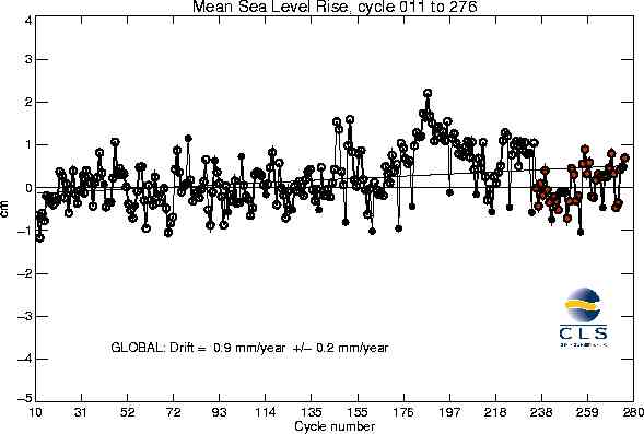
Global MSL variation according to Topex/Poseidon satellites The Topex/Poseidon project also has established a set of tide gauges on islands in the Pacific Ocean fitted with GPS equipment. Their purpose is to calibrate the satellites to a still greater level of accuracy. In time, they should render tide gauge data redundant. The IPCC predicts that its sea level rise rate estimate of +1.8 mm/yr will accelerate during the 21st century to around 5 mm/yr. As the figure above shows, the current sea level rate of rise after cycle 276 is 0.9 mm/yr, half the rate claimed for the last 100 years, and less than 1/5 the rate claimed for the 21st century. Not only has recent sea level rise not matched the 20th century rate claimed by the IPCC, the idea that an acceleration might be underway as a result of climatic warming is contradicted by satellite temperature data. Although the IPCC claims the 1990s have been characterised by human-induced warming, the accelerated sea level rise they anticipate from that warming simply has not materialised. As the graph above also shows, even the small amount of sea level rise there has been is due primarily to the intense El Niño of 1997-98 which has been demonstrated to cause a temporary rise in global sea level (although it causes a local fall in level in the western Pacific). Sea level following the El Niño is now much the same as it was prior the event. The CNES, based in Toulouse, France, and co-sponsor of the satellites, also attributes the sea level rise since 1992 to the 1997-98 El Niño. Once there is a longer period of satellite data, the effect of that El Niño will diminish in the statistically-averaged sea level result. If the effect of the El Niño is excluded from the sea level result, scarcely any sea level rise is registered by Topex/Poseidon. John L Daly is the science advisor for the Greening Earth Society Source: www.greeningearthsociety.org from "Testing the Waters: A Report on Sea Levels" based on CNES online MSL data for Topex/Poseidon cycle 276 and V Gray's "The IPCC Future Projections: Are They Plausible?" published in Climate Research, volume 10 pages 155-162, 1998. Please see the Greening Earth's Society's website for lots more detail.
On the other hand... Global Warming Is "Twice as Bad as Previously Thought"by Steve Connor Global warming might be twice as catastrophic as previously thought, flooding settlements on the British coast and turning the interior into an unrecognisable tropical landscape, the world's biggest study of climate change shows. Researchers from some of Britain's leading universities used computer modelling to predict that under the "worst-case" scenario, London would be under water and winters banished to history as average temperatures in the UK soar up to 20ºC higher than at present. Globally, average temperatures could reach 11ºC greater than today, double the rise predicted by the Intergovernmental Panel on Climate Change, the international body set up to investigate global warming. Such high temperatures would melt most of the polar icecaps and mountain glaciers, raising sea levels by more than 20 feet. A report this week in The Independent predicted a 2ºC temperature rise would lead to irreversible changes in the climate. The new study, in the journal Nature, was done using the spare computing time of 95,000 people from 150 countries who downloaded from the internet the global climate model of the Met Office's Hadley Centre for Climate Prediction and Research. The program, run as a screensaver, simulated what would happen if CO2 levels in the atmosphere were double those of the 18th century, before the Industrial Revolution, the situation predicted by the middle of this century. David Stainforth of Oxford University, the chief scientist of the latest study, said processing the results showed the Earth's climate is far more sensitive to increases in man-made greenhouse gases than previously realised. The findings indicate a doubling of CO2 from the pre-industrial level of 280 parts per million would increase global average temperatures by between 2ºC and 11ºC. Mr Stainforth said: "An 11ºC-warmed world would be a dramatically different world... There would be large areas at higher latitudes that could be up to 20ºC warmer than today. The UK would be at the high end of these changes. It is possible that even present levels of greenhouse gases maintained for long periods may lead to dangerous climate change... When you start to look at these temperatures, I get very worried indeed." Attempts to control global warming, based on the Kyoto treaty, concentrated on stabilising the emissions of greenhouse gases at 1990 levels, but the scientists warned that this might not be enough. Mr Stainforth added: "We need to accept that while greenhouse gas levels can increase we need to limit them, level them off then bring them back down again." Professor Bob Spicer, of the Open University, said average global temperature rises of 11ºC are unprecedented in the long geological record of the Earth. "If we go back to the Cretaceous, which is 100 million years ago, the best estimates of the global mean temperature was about 6ºC higher than present," Professor Spicer said. "So 11ºC is quite substantial and if this is right we would be going into a realm that we really don't have much evidence for even in the rock [geological] record." Myles Allen, of Oxford University, said: "The danger zone is not something we're going to reach in the middle of the century; we're in it now." Each of the hottest 15 years on record have been since 1980. Steve Connor is the science editor Source: news.independent.co.uk 27 January 2005
Britain Faces Big Chill as Ocean Current Slowsby Jonathan Leake Climate change researchers have detected the first signs of a slowdown in the Gulf Stream - the mighty ocean current that keeps Britain and Europe from freezing. They have found that one of the "engines" driving the Gulf Stream - the sinking of supercooled water in the Greenland Sea - has weakened to less than a quarter of its former strength. The weakening, apparently caused by global warming, could herald big changes in the current over the next few years or decades. Paradoxically, it could lead to Britain and northwestern and Europe undergoing a sharp drop in temperatures. Such a change has long been predicted by scientists but the new research is among the first to show clear experimental evidence of the phenomenon. Peter Wadhams, professor of ocean physics at Cambridge University, hitched rides under the Arctic ice cap in Royal Navy submarines and used ships to take measurements across the Greenland Sea. "Until recently we would find giant ‘chimneys’ in the sea where columns of cold, dense water were sinking from the surface to the seabed 3,000 metres below, but now they have almost disappeared," he said. "As the water sank it was replaced by warm water flowing in from the south, which kept the circulation going. If that mechanism is slowing, it will mean less heat reaching Europe." Such a change could have a severe impact on Britain, which lies on the same latitude as Siberia and ought to be much colder. The Gulf Stream transports 27,000 times more heat to British shores than all the nation’s power supplies could provide, warming Britain by 5 - 8º C. Wadhams and his colleagues believe, however, that just such changes could be well under way. They predict that the slowing of the Gulf Stream is likely to be accompanied by other effects, such as the complete summer melting of the Arctic ice cap by as early as 2020 and almost certainly by 2080. This would spell disaster for Arctic wildlife such as the polar bear, which could face extinction. Wadhams’s submarine journeys took him under the North Polar ice cap, using sonar to survey the ice from underneath. He has measured how the ice has become 46% thinner over the past 20 years. The results from these surveys prompted him to focus on a feature called the Odden ice shelf, which should grow out into the Greenland Sea every winter and recede in summer. The growth of this shelf should trigger the annual formation of the sinking water columns. As sea water freezes to form the shelf, the ice crystals expel their salt into the surrounding water, making it heavier than the water below. However, the Odden ice shelf has stopped forming. It last appeared in full in 1997. "In the past we could see 9 - 12 giant columns forming under the shelf each year. In our latest cruise, we found only 2 and they were so weak that the sinking water could not reach the seabed," said Wadhams, who disclosed the findings at a meeting of the European Geosciences Union in Vienna. The exact effect of such changes is hard to predict because currents and weather systems take years to respond and because there are two other areas around the north Atlantic where water sinks, helping to maintain circulation. Less is known about how climate change is affecting these. However, Wadhams suggests the effect could be dramatic. "One of the frightening things in the film The Day After Tomorrow showed how the circulation in the Atlantic Ocean is upset because the sinking of cold water in the north Atlantic suddenly stops," he said. "The sinking is stopping, albeit much more slowly than in the film - over years rather than a few days. If it continues, the effect will be to cool the climate of northern Europe." One possibility is that Europe will freeze; another is that the slowing of the Gulf Stream may keep Europe cool as global warming heats the rest of the world - but with more extremes of weather. Source: www.timesonline.co.uk The Sunday Times - Britain 8 May 2005
Aqua Makes a Splashby Dr David Whitehouse
In this brightness image, ice and snow cover show up in white and yellow, A dramatic new view of the Earth has emerged from the first few weeks of the orbital checkout of Aqua, the satellite designed to study the world's water. Aqua has sent back pictures of sea-surface temperature and brightness - and they are stunning. Aqua is a joint project between the US, Japan and Brazil. Its six sensors will study the infrared and the visible spectrum to determine cloud properties, sea-surface temperatures and ocean colour. As well as the water cycle, Aqua will conduct studies of the Earth's radiation balance. It will also look at small particles in the atmosphere, and trace gases, such as ozone, carbon monoxide, and methane. It also carries a sensor that will measure atmospheric temperatures with an accuracy of 1º Celsius in a one-kilometre-thick (0.6 mile) layer throughout the troposphere, the lowest part of Earth's atmosphere. Science data have currently been received from five of Aqua's six instruments. It is Japan's Advanced Microwave Scanning Radiometer (AMSR-E) which has produced the first geophysical product: a global map of sea-surface temperatures. Researchers say the instrument is an outstanding performer and shows the high quality of the detail the sensor will produce even when it is cloudy. AMSR-E began sending data on 1 June. Initial (uncalibrated) data have produced impressive images of the Earth's surface. Recently however, AMSR-E has had some problems that engineers are evaluating. In the brightness image, ice and snow cover show up in white and yellow, desert areas in shades of green, other land areas in dark colours, and oceans in shades of blue. "These engineering images are great, which tells us that we have a healthy spacecraft and all instruments are performing nominally. Everything indicates that we are on schedule to go operational in early September," said Phil Sabelhaus, Aqua's Project Manager at Nasa's Goddard Space Flight Centre.
In this global map of sea-surface temperatures, Dr Whitehouse is the science editor for the BBC News online Source: news.bbc.co.uk Friday 28 June 2002 See also:
Fact: 46,000 Pieces of Plastic Float on Each Square Mile of Seaby Niall Ferguson There is a wonderfully sinister poem by Edgar Allan Poe, "The City in the Sea", which depicts an Atlantis-like metropolis lost beneath the "melancholy waters" of a "lurid sea". The sea lures us from our cities to its shores at this time of year. From Cowes to Cancun, we frolic in its waves. This summer, however, I cannot help thinking of Poe's lines as a kind of prophecy:
Why am I haunted by this image of a sunken city? I think because it symbolises the coming revenge of the sea on mankind for nearly a century of mistreatment. For it was exactly 99 years ago that Leo Hendrik Baekeland invented the first plastic based on a synthetic polymer - Bakelite - and ushered in the age of plastic. From that moment onward, a new kind of pollutant entered the sea; one that took a century or more to degrade. The results of a century of plastic pollution are glaringly apparent along the South Wales coast, our family haunt each August. Along certain stretches of beach near Porthcawl you cannot walk without stepping on a plastic bottle. All too often, as I swim, I encounter empty crisp packets, as silver as mackerel but square and dead. Plastic bags float like spectral jellyfish in the water; others are blown inland, impaling themselves hideously on the marram grass in the dunes. I and other local volunteers periodically attempt to clear up this garishly coloured flotsam and jetsam. As we toil, I inwardly curse those responsible. Local louts. Vicious visitors. Insouciant seamen. It isn't like this, I mutter to myself, on the bonny Isle of Coll, where we used to have our holidays. Dream on. For the problem of coastal pollution is ubiquitous. Practically the entire British coastline is afflicted, as last week's BBC documentary Seawatch pointed out. According to the Marine Conservation Society's latest annual survey, which covers more than a hundred miles of British coastline, there has been a 90% increase in the density of litter over the past decade. More than a third of the rubbish found in the latest survey consisted of fragments of plastic, food wrappers, bottle lids and cotton buds. And it's not just Britain. The plastic plague is a global epidemic. According to the United Nations Environment Programme, there are approximately 46,000 pieces of plastic floating on every square mile of the world's oceans. The problem is more than merely æsthetic. Last week the Los Angeles Times carried a shocking report from Midway Atoll, which is about as isolated a spot as the world has to offer, 2,800 miles west of California and 2,200 miles east of Japan. Hardly anyone lives there, so the number of crisp packets chucked in the sea can't be large. And yet birdlife on Midway is being devastated as albatrosses inadvertently feed their chicks lethal fragments of plastic picked up from what's known as the Eastern Garbage Patch, a virtual island of trash formed by the currents of the North Pacific subtropical gyre. The Patch is not so much a city in the sea as a municipal dump on the sea. Albatrosses are not the only victims. Leatherback turtles in British waters die lingering deaths after swallowing plastic bags. Untold numbers of fish and marine mammals are killed each year by discarded fishing nets, compounding the chronic problem of over-fishing. There are costs to humans, too. Each year since 1969 human consumption of fish has risen by 8%, but (according to the UN Food and Agriculture Organisation) around 16% of the world's principal fish stocks have been depleted, meaning that the tuna could one day go the way of the dodo. As for those toxic algal blooms that have been plaguing the Italian coast, they may well be stimulated by man-made agents such as chemical fertilisers, which get washed down rivers into the sea. Some environmentalists worry more about the earth and the air than about the sea. They fret about the receding rainforests and the warming atmosphere. Yet roughly 70% of the earth's surface is water, not land. The fact that we are systematically replacing cod with Coke bottles deserves more attention than it gets - a point well made in the report issued earlier this summer by the UN Environment Programme and the World Conservation Union. But what to do? In economic terms, the pollution of the oceans is the ultimate "tragedy of the commons". As popularised by the ecologist Garrett Hardin, the tragedy is that an area of open pasture will tend to be depleted and eventually destroyed if the benefits of exploitation accrue to individuals, while the costs of exploitation (what economists like to call the "negative externalities") are shared. When people dump rubbish in the sea they are acting like a medieval farmer who over-grazed the common land. The rubbish is disposed of at no cost to the polluter, just as the farmer's cattle got fed for free. But everyone loses if the sea becomes a cesspit, just as everyone lost if the commons became a desert. There are two classic solutions to this kind of problem. The first is regulation by a higher authority. In the case of the oceans, this solution is already in place, in the form of the 1994 United Nations Convention on the Law of the Sea. The problem, as with so many UN documents, is the lack of effective enforcement. So what about the alternative solution, namely privatisation? In early-modern England, common land was progressively "enclosed": claimed and fenced by individual landowners. In theory, of course, some parts of the sea have already been enclosed, in that countries with coastlines lay claim to coastal waters and fisheries. British coastal waters extend for 12 nautical miles from shore; the exclusive fishing zone we claim is 200 nautical miles wide. Yet even if all such claims were universally respected, vast tracts of the world's oceans would remain "no man's water". In any case, it is far from clear that national governments are effective custodians even of their own coastal waters, since it is precisely there that most pollution of the sea occurs. Moreover, it is national governments that effectively subsidise over-fishing. This, then, could be the ultimate tragedy of the commons. "The men of the hydrocarbon age," a future historian may write, "busied them-selves with extracting oil from under the land and the sea bed. Much of the oil they burned to heat their homes, fuel their vehicles and power their factories. But some of it they used to make plastic, a substance they valued for its durability. Perversely, men employed this almost indestructible petroleum product for quite ephemeral purposes. In particular, they obsessively wrapped it around everything they ate and drank. The result was that each human meal generated a substantial quantity of waste in the form of soiled plastic containers. Some they burned. Some they buried in huge holes. But a considerable quantity of this plastic ended up in the sea. Because plastic tends to float, the rubbish gradually came to cover ever wider areas of the ocean's surface. Currents and tides deposited a proportion on beaches all over the world, but much of it remained out of sight in so-called Garbage Patches. As the principal victims of plastic pollution were birds, fish and sea mammals, men paid little attention. Only a few recalled Edgar Allan Poe's lines:
So enjoy the seaside. But beware the coming tsunami of trash." Niall Ferguson is Laurence A Tisch Professor of History at Harvard University www.niallferguson.org © Niall Ferguson, 2006 Source: www.telegraph.co.uk 6 August 2006
For pages on several other types natural disasters - including lightning strikes, tornados, hurricanes, volcanoes and more - as well as some great satellite and tree photos, clicking
the "Up" button immediately below takes you to the Table of Contents page for this Environment section. |