Animals
 Animation
 Art of Playing Cards
 Drugs
Drugs Education
 Environment
 Flying
 History
 Humour
 Immigration
 Info/Tech
 Intellectual/Entertaining
 Lifestyles
 Men
Men Money/Politics/Law
 New Jersey
 Odds and Oddities
 Older & Under
 Photography
 Prisons
 Relationships
 Science
 Social/Cultural
 Terrorism
 Wellington
 Working
 Zero Return Investment
Searching High and Wide
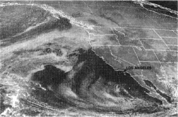
California HighA satellite has no conscience. - Edward R Murrow
This weather satellite photo was taken at 2pm Tuesday 7 November 2000 The jet stream carried substantial moisture from a strong, Pacific low-pressure system into the Northwest. Rotation by a fast-moving low pressure in the Great Basin produced cold, gusty offshore winds that cleared skies all across California. Source: Los Angeles Times Wednesday 8 November 2000
I don't see a bit of smog in LA. I wish I had been there!
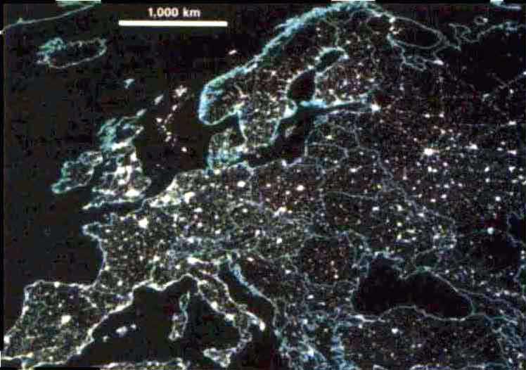
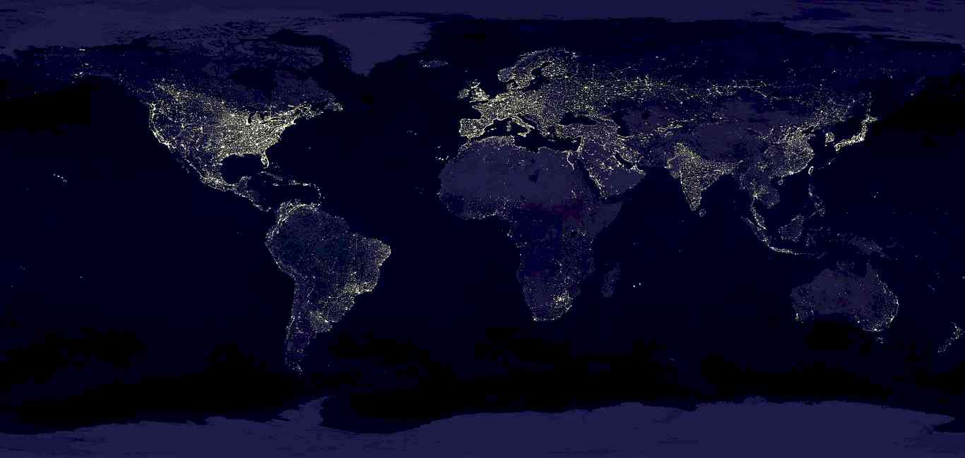
Night Lights
by Karen Southwell New satellite images of Earth at night give the most complete view of global human settlement yet obtained. The Operational Linescan System (OLS) detects visible and near-infrared emissions resulting from human activity. These maps not only reveal a fascinating view of worldwide "light pollution," but they also serve as indirect tracers of international greenhouse gas production. The OLS sensors are part of the Defense Meteorological Satellite Program, and have been operational for two decades. But previous images suffered from limited area coverage and were unable to filter out misleading signals, such as grassfires. Using new techniques to process digitally archived data, C D Elvidge and colleagues (Global Change Biology 3, 387 - 395; 1997) have circumvented these problems. By analysing a series of images acquired at different times during 1994 - 95, they've built up maps of the permanent light and heat emission from the Americas, Asia, and Europe (the one shown above). By selecting observations acquired when there was little moonlight (which can bounce off clouds and produce spurious signals), they've achieved optimal sensitivity to faint, small sources at ground level. Variations in the density of emitted light are striking but not surprising - certainly, the major cities can't hide. However, the maps also facilitate comparisons between the illuminated area of each country [or state], and statistics such as those for population density and known carbon emissions. The OLS data suggest that, allowing for certain biasing factors, these statistics directly correlate with the area of lit regions. So the results may provide a way of gauging different national/state/regional contributions to greenhouse gas production. This has wide implications for climatic change. Source: Nature Volume 390 6 November 1997
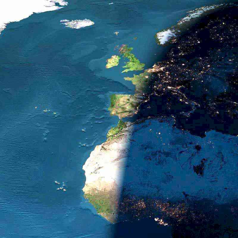
European Sunset
A Digital Sunset Over Europe and Africa No single spacecraft or astronaut took this picture: it is a digital composite of archived images taken by several Earth-orbiting satellites and ocean-faring ships. Similar images can be digitally stitched together for any Earth location by John Walker's Earth and Moon Viewer website. Specifically, the daytime land images were taken by the MODIS instrument on NASA's Terra satellite, while the nighttime images were taken by the DMSP satellites. This image is different from what an astronaut would see for reasons including a complete lack of clouds and an unrealistic exaggeration of lights and contrasts. Source: antwrp.gsfc.nasa.gov
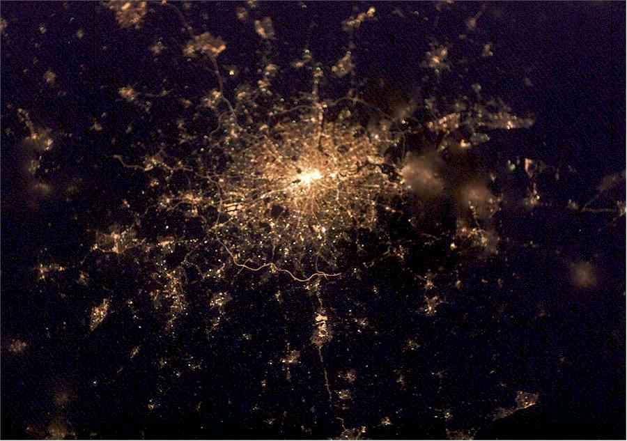
What Galaxy Is This?
London at Night Do you recognise this intriguing globular cluster of stars? It's actually the constellation of city lights surrounding London, England, planet Earth, as recorded with a digital camera from the International Space Station. Taken in February 2003, north is toward the top and slightly left in this nighttime view. The encircling "London Orbital" highway by-pass, the M25 (... but not Messier 25), is easiest to pick out south of the city. Even farther south are the lights of Gatwick airport and just inside the western (left hand) stretch of the Orbital is Heathrow. The darkened Thames river estuary fans out to the city's east. In particular, two small "dark nebulae" - Hyde Park and Regents Park - stand out slightly west of the densely packed lights at the city's core. Source: antwrp.gsfc.nasa.gov
Light on the Subject
Source: antwrp.gsfc.nasa.gov - visit them for a huge version
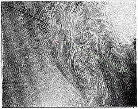
Give It a Twirl
by Helke Langenberg Only with the advent of space oceanography have spiral structures in the sea become recognised phenomena. They have proved rewarding, if difficult, subjects for research. Walter Munk and colleagues have analysed 400 photographs from space that show these attractive patterns on the ocean surface (Proceedings of the Royal Society of London, A 456, 1217-1280; 2000). They restricted their investigation to small spirals, 10 - 25 km in diameter, that last for only about a day, excluding features such as the rings in the Gulf Stream that can be up to 300 km across and last for years. It turns out that most spirals rotate in the same direction as storm cyclones: anticlockwise and clockwise in the Northern and Southern Hemispheres, respectively. Munk et al find that all potential mechanisms favour the same direction of motion because of the Earth's rotation, cyclonic spirals form more easily and are more stable. Moreover, cyclonic rotation is more likely to be visible, because streaks on the sea surface that can be twisted into spirals are more likely to occur where cyclones are created. For much the same reasons, the Mediterranean in autumn is particularly rich in visible spirals: the seasonal, strong winds, followed by calm conditions, are ideal generators of streaks. The picture here shows an example of fully developed spirals off Crete in October 1984. Similar eddies have been explained as stemming from instabilities at the interface between two water masses of different densities. But that cannot apply to many of the images studied by Munk et al. Rather, they think that the driving force is often turbulence generated at the boundary of two water masses moving relative to each other. As the authors remark, however, there is certainly more than one way to make an ocean spiral. Which may explain why they are such common features of the seascape. Source: Nature Vol 405 22 June 2000
The Sky Is a Mirror
I think satellite photos convey something of great power. I would dearly love to see the Earth from orbit. I certainly understood John Glenn's desire to experience space again. I was glad he made it into orbit, then back home again safely. If being launched becomes commonplace before I get too old to try it, maybe we'll run into each other in the Stratosphere Bar and Grill someday! See also:
For pages on several types of natural disasters - including lightning strikes, tornados, hurricanes, volcanoes, floods, global warming and
more - as well as some great tree photos, clicking the "Up" button immediately below takes you to the Table of Contents page for this
Environment section. |